Quick summary: Learn how to collect, verify, and manage smallholder farmer data for EUDR-compliant cocoa traceability. Step-by-step guide + TraceX platform overview.
Managing smallholder data for cocoa traceability means digitally onboarding each farmer with geotagged plot boundaries, capturing transaction records at the farmgate, and linking every bag of cocoa to a verified, tamper-proof data record. When done correctly, this data chain satisfies EUDR Due Diligence Statement (DDS) requirements and gives buyers the farm-level visibility they demand.
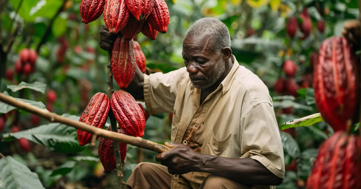
The challenge? More than 90% of cocoa is produced by smallholder farmers in West Africa, Southeast Asia, and Latin America many without smartphones, internet access, or formal land titles. Standard enterprise software fails here. You need a system built for the last mile.
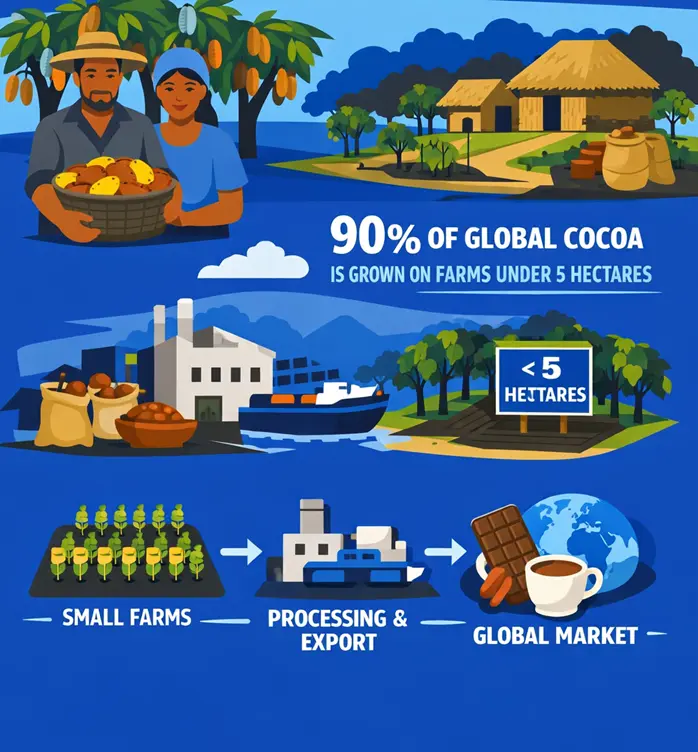
The global cocoa supply chain depends on an estimated 5-6 million smallholder farmers, and about 90% of global cocoa is produced on farms under 5 hectares.
These farmers are not registered in centralized databases. They don’t have GPS coordinates attached to their land. Many operate entirely in local languages, with no digital footprint. And under EUDR, every cocoa shipment entering the EU must now be accompanied by verifiable geolocation data proving it was not produced on deforested land.
If you’re relying on spreadsheets or manual collection, you’re building on a foundation that will fail an audit. The question isn’t whether you need a digital system it’s how to implement one that actually works at the farmer level.
Exporting cocoa to the EU? Make sure you meet EUDR requirements
Before building a data collection system, you need to know exactly what data the EUDR mandates. The regulation requires operators to submit a Due Diligence Statement (DDS) covering four data categories for each cocoa shipment.
| Data Category | What’s Required | Why It Matters | Collection Challenge |
|---|---|---|---|
| Geolocation | GPS polygon of each farm plot producing cocoa in the shipment | Validated against JRC deforestation datasets | Farmers don’t know their coordinates; field agents must map each plot manually |
| Land Tenure / KYC | Farmer identity, land ownership or use rights | Required for audit trail and risk assessment | Many farmers have informal arrangements; no formal title documents |
| Volume and Lot Data | Quantity sourced per farmer per transaction, linked to GPS plot | Chain-of-custody from plot to shipment | Paper-based farmgate records are easily lost or falsified |
| Deforestation-Free Declaration | Attestation that production didn’t occur on deforested land after Dec 31 2020 | Core legal requirement for EU market access | Requires cross-referencing satellite imagery against plot coordinates |
Notice what’s missing from most existing data systems: the link between a physical farm plot (GPS polygon), the farmer identity (KYC), and the batch-level transaction (volume, date, price). This three-way link is what transforms fragmented records into an EUDR-valid data package.

Here’s the operational framework used by successful cocoa exporters who’ve achieved EUDR-ready traceability across thousands of smallholder farmers. Each step maps to a specific data problem and a specific technology requirement.
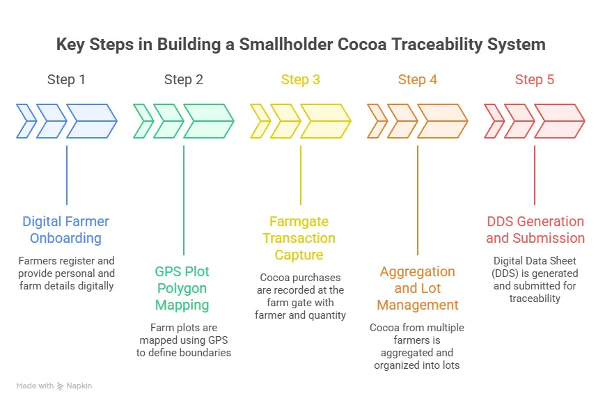
The critical design requirement here is offline-first functionality. Field agents in Cote d’Ivoire, Ghana, or Sulawesi often collect data in areas with no mobile data coverage. The app must capture and queue all records locally, syncing to the central platform when connectivity is available.
Multilingual support is equally critical. A data collection app that operates only in English will produce systematic errors in West African and Indonesian supply chains agents default to local languages, and transcription errors corrupt GPS coordinates and farmer IDs.
This step is where most manual systems fail completely. A single GPS point does not satisfy EUDR requirements you need polygon data showing the actual cultivation boundary. Collecting this accurately for 2,000 farmers in a fragmented landscape is a significant field operation requiring trained agents and the right tooling.
Plot size also matters for risk scoring. A 0.5-hectare plot mapped precisely is far more defensible in an audit than a rough estimate entered from a desk.
Missing geolocation data can block your shipments – learn EUDR requirements
This is the chain-of-custody step. Without it, you can prove a plot is deforestation-free but you can’t prove the cocoa in your shipment actually came from that plot. The linkage between GPS-mapped plot, identity-verified farmer, and QR-coded batch is the heart of defensible traceability.
Cocoa supply chains are inherently fragmented, with thousands of smallholder farmers selling through intermediaries before reaching exporters. In this case, a cocoa exporting company depended on Licensed Buying Agents (LBAs) to aggregate beans from approved farmers and supply them to warehouses for export.
However, this multi-layered procurement model created challenges in visibility, traceability, and data consistency, making it difficult to track sourcing, validate suppliers, and ensure compliance.
By digitizing cocoa procurement, the company was able to capture and standardize farmer and transaction data, improve traceability across LBA-driven sourcing networks, enhance transparency from farm to warehouse, and strengthen compliance and reduce sourcing risks.
The result: Streamlined procurement operations, improved data reliability, and better control over cocoa sourcing.
See how digital procurement can transform traceability in cocoa supply chains
Aggregation is where data often falls apart in manual systems. Once cocoa from 200 farmers is combined at a cooperative store, it becomes nearly impossible to reconstruct the contributing farms without a digital system that tracked each transfer.
Aggregation can break traceability learn how to fix it
Don’t risk rejection, get your DDS filing process right
The cocoa traceability market is full of tools that look right on a product page but fail in the field. Here’s an honest comparison of approaches, evaluated against the operational realities of smallholder supply chains.
| Approach | Offline Capability | GPS Polygon Mapping | EUDR DDS Output | Smallholder Scale | Verdict |
|---|---|---|---|---|---|
| Spreadsheets / Excel | Yes (manual) | No | No | Breaks at over 200 farmers | Not viable for compliance |
| Generic ERP / SCM Software | Partial | Rarely | No native support | Not designed for it | Fails at last mile |
| Commodity Certification Tools (Fairtrade, RA) | No | Limited | Not EUDR-native | Cooperative level only | Compliance gap not sufficient alone |
| Purpose-built Traceability Platforms (e.g. TraceX) | Yes – offline-first mobile | Yes GPS polygon + satellite validation | Yes – automated DDS with TRACES API | Designed for 100s-1000s of farmers | Purpose-fit for EUDR cocoa compliance |
TraceX Technologies built its Sustainable Sourcing and Regulatory Compliance Platform specifically for the realities of emerging market supply chains including cocoa in West Africa, Southeast Asia, and South America. The platform has been deployed by companies and organizations that operate at the intersection of large-scale procurement and last-mile smallholder engagement.
The architecture addresses the specific pain point compliance managers articulate most often: ‘We can’t manually collect GPS data from 2,000 farmers every season.’ TraceX does this through a trained field agent model your agronomists or cooperative managers use the mobile app; data flows automatically to your compliance dashboard.
For development organizations and NGOs working on cocoa farmer livelihood programs, the same platform also captures impact metrics income data, input usage, training completion satisfying donor reporting requirements alongside commercial traceability needs.
Based on common patterns in EUDR readiness assessments across cocoa supply chains, these are the most damaging data management errors and how to avoid them.
EUDR requires farm boundary polygons not centroid coordinates. A single GPS point placed in the middle of a farm plot does not satisfy the regulation’s geolocation requirements. Exporters who rushed to collect ‘GPS data’ using simple lat/long entries will need to re-collect. Polygon mapping takes longer per farm, but it’s the only data that’s legally valid.
GeoJSON errors can lead to DDS rejection – learn how to avoid them
Entering three seasons of paper purchase records into a digital system before a compliance audit is a red flag, not a solution. EU auditors look for contemporaneous records data captured at the time of transaction. Retroactive digitization creates the appearance of compliance without the substance.
Many exporters have cooperative-level records but no plot-level data. The EUDR requires geolocation at the individual farm plot level, not just cooperative membership. If your data stops at ‘Farmer X belongs to Cooperative Y in Region Z,’ it’s insufficient for DDS submission.
Farms change. Farmers move, sell land, or expand to new plots. A traceability system that captures data once and doesn’t maintain it across seasons will drift out of accuracy within 12-18 months. Plan for annual re-verification of farmer profiles and plot boundaries.
EUDR’s deforestation cutoff is December 31, 2020. Any farm plot that was deforested after that date even if it’s been producing cocoa since 2022 is non-compliant. Satellite cross-validation against historical imagery datasets (Hansen, JRC) is the only way to verify this programmatically at scale.
This phased implementation timeline assumes a mid-market cocoa exporter working with 500-2,000 smallholder farmers across 2-3 sourcing regions.
| Phase | Timeline | Actions | Milestone |
|---|---|---|---|
| Phase 1: Foundation | Days 1-30 | Platform setup, field agent training, pilot cooperative selection (50-100 farmers) | 80%+ of the supplier base digitally onboarded with plot polygons |
| Phase 2: Scale | Days 31-60 | Full farmer onboarding across all sourcing regions, farmgate transaction capture live | 80%+ of the supplier base is digitally onboarded with plot polygons |
| Phase 3: Compliance | Days 61-90 | DDS test submissions, satellite validation runs, ERP integration, first live TRACES submission | First EUDR-compliant DDS submitted for active cocoa shipment |
The 90-day window is achievable when three conditions are met: leadership commitment to allocate field agent time, a platform that’s genuinely designed for offline and low-connectivity environments, and a vendor that provides implementation support, not just software.
EUDR compliance is mandatory. Understand the requirements before it’s too late
Managing smallholder data is no longer just an operational task; it’s the foundation of compliant, transparent, and resilient cocoa supply chains. As regulations tighten and buyers demand proof of origin, companies must move beyond spreadsheets and fragmented records to structured, verifiable data systems. By digitizing farmer profiles, mapping farms, and linking data to procurement and batches, businesses can achieve true end-to-end traceability. Ultimately, those who invest in reliable smallholder data management won’t just meet compliance requirements; they’ll build stronger supplier relationships, reduce sourcing risks, and gain long-term market trust.
EUDR requires GPS polygon geolocation for every farm plot contributing to a cocoa shipment, farmer KYC identity information, batch-level volume and transaction records, and a declaration that production occurred on land that was not deforested after December 31, 2020. All data must be verifiable and audit-ready.
GPS data collection for smallholder farmers is conducted by trained field agents using offline-capable mobile apps. The agent walks the boundary of each farm plot while the app records a GPS polygon. Farmers don’t need their own devices. Data is queued offline and synced when the agent reaches connectivity. Platforms from TraceX are specifically designed for this field agent model in low-connectivity environments.
Existing certifications can support your compliance case but are not sufficient on their own. EUDR has specific geolocation requirements (GPS polygon per plot) that most certification schemes don’t capture at the required granularity. Certification data can be imported and cross-referenced, but you’ll need to collect plot-level GPS data as a minimum additional step.
With a well-designed platform and trained field agents, onboarding 1,000 farmers typically takes 4-8 weeks, depending on geographic concentration, accessibility, and the number of field agents deployed. Digital onboarding with GPS polygon mapping takes approximately 45-90 minutes per farmer in the field. Phased onboarding, starting with your highest-volume cooperative relationships, is the most efficient approach.
If a GPS polygon is cross-validated against satellite datasets (JRC, Hansen) and a deforestation event is detected after December 31, 2020, that plot is non-compliant under EUDR. You cannot include cocoa from that plot in EU-destined shipments. Modern traceability platforms like TraceX provide ongoing monitoring alerts so you can identify risk early, engage with the farmer on remediation, or adjust sourcing volumes before a shipment is compromised.